Summary
This route continues the circuit of England's South East Coast begun by Route C (Whitstable to Dover). You follow National Cycle Route 2 along the cliffs between Dover and Folkestone. Although close to the busy A20, there are airy views out to sea. There is an interesting optional diversion to visit Samphire Hoe, accessed by a tunnel under the chalk downs, and the moving Battle of Britain Memorial at Capel-le-Ferne, before descending to Folkestone. The newly instated Lower Leas Country Park beneath the cliffs provides a pleasant exit route from the town (or you can follow the sea wall), and the route joins the sea wall at Sandgate to take you on to Hythe. There is then a short inland diversion to avoid Hythe Ranges, making use of the Royal Military Canal towpath. Leave NCN2 to rejoin the sea wall at Dymchurch redoubt for a fantastic stretch of cycling right along the coast to Dungeness, much of it along the wide and traffic free sea wall. At low tide it is possible to cycle along the broad hard-sand beach between Littlestone and Greatstone. You cross the shingle plain to Dungeness Lighthouse and Power Station, then via the RSPB Dungeness Reserve to the village of Lydd, where NCN2 is re-joined to take you to the sea wall again for another airy ride to Camber, then by roadside track into the attractive and fascinating town of Rye. (For the next section, Rye to Eastbourne, see here.) (For more 'Cycling from Guildford' routes see here.)
Travel: There is no direct train from Rye to Dover, so it is best to park at Ashford station, where the line splits to Rye and Dover respectively. Park in the pay parking (large 24x7 secure car park), then take the train to Dover Priory to start the ride. Return from Rye station.
Map:
GPX: You can download the Google map info, as a KML/KMZ file, then convert to GPX using a site like GPS Visualiser, or get the route from the cycle.travel website. You download and use any such data entirely at your own risk.
Distance: 43 miles
Surface: Mainly good surfaces (tarmac path or road, concrete sea wall). The track across the RSPB Dungeness Reserve is shingly and quite rough.
Route Variations: The new Cycling UK Cantii Way includes this route. It deviates by taking roads around the back of Folkestone (which can be busy with traffic rat-running to Dover Port at busy times) plus a track over Sene Valley Golf Course, and a longer inland diversion between Hythe and Dymchurch via Burwash - see my blog here.
You could follow NCN2 all the way: it goes inland from Hythe to Lydd , which I presume to be pleasant enough, but it misses the sea wall ride and Dungeness which are USPs of this route.
See also my blog for a circular tour around Romney Marsh visiting some of the area's historic churches.
Directions (see map):
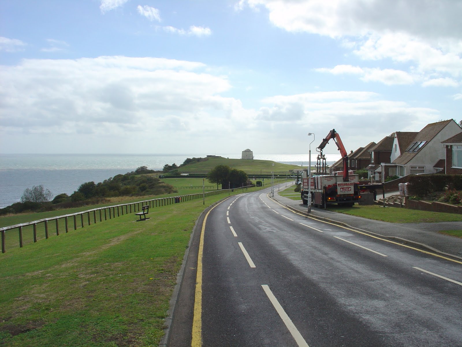
From Dover Priory Station, make your way down to the harbour frontage, where you, pick up NCN2 signs and follow the Old Folkestone Road through a housing estate, then over a bridge over the A20 to the cycle path and head on towards Folkestone. If you wish to visit Samphire Hoe, take the obvious branch to the tunnel to your left after a short distance, and make your way down to the Visitor Centre. The route round the Hoe is easily followed. Returning to the NCN2 (recently resurfaced with good tarmac), continue dramatically along the cliff top past the concrete Sound Detection 'Mirror' above Abbots Cliff, then join the B2011 briefly before branching left on the Old Dover Road into Capel-Le-Ferne. Look out for the Clifftop cafe on your left if you’re hungry. You rejoin the B2011, where the Battle of Britain Memorial will easily be found on the left.
A little way on, fork right onto Crete Road East, then left down a steep lane to rejoin the B2011/Dover Hill, then promptly turn left into Dover Road, left on a footpath through to Stanbury Crescent (it should all be signed NCN2). Carry on following signs and you should end up coming down the coast road into Folkestone, passing the prominent Martello Tower on your left, and reaching the harbour.
Leave the harbour via Marine Parade. You may either head left across the currently vacant old funfair site to join the sea wall directly, or continue on into and through the pleasant Lower Leas Coastal Park. If you chose the latter, make sure before you come to the park exit to make your way down to join the sea wall. The sea wall promenade now gives excellent cycling all the way to Hythe. Here, an inland diversion is necessary to avoid Hythe Ranges. at which point you have to follow the NCN2 signs inland for while. Near the end of the Hythe promenade, take the small access road on your right and go across South Road into a park. Head north on the path and join the Royal Military Canal (which makes quite a grand water feature for such a small town). Follow the towpath west along the Royal Military Canal for a couple of miles, then back on the road again at Burmarsh Road. Follow this road until it crosses the RMC again, then immediately turn left into Botolph's Bridge Road: this is where you depart from the NCN2 in order to return to the sea wall at Dymchurch Redoubt, after a short stretch next to the A259.
Now its plain sailing (or cycling) along the sea wall passing through Dymchurch and St Mary's Bay to Littlestone, with Dungeness Nuclear power Station looming up ahead of you. The sea defences have recently been extensively renovated, providing an excellent wide shared use path. There is a short stretch at the Dymchurch beach area where cycling is prohibited and you'll have to get off and push. The refurbished area ends at St Mary's, where the path narrows, but is still a good concrete surface to Littlestone. Here, you rejoin the coastal road, but, if the tide permits, you could take the opportunity to ride along the fabulous sandy beach: I got as far as Greatstone, but maybe you can go further. Then, its back on the seaside road through Lydd-on-Sea to the point where the road bends sharp right by the Pilot Inn.
Here you could stay on the main road to Lydd, but it is much more interesting to make the diversion on the road across the shingle 'desert' to the power station (you can't miss it!), the Old Lighthouse and the terminus of the Romney Hythe and Dymchurch Railway. Then follow the unexpected path around the power station perimeter fence, escape along the power station access road, and then take the rough bridleways across the RSPB Dungeness Reserve, and onward to the outskirts of Lydd on the Lydd Ranges perimeter road, where you pick up the NCN2 again heading towards Camber and Rye. There is a dedicated roadside cycle path most of the way to the sea wall at Jury's Gap (to your left is the extensive Lydd Firing Range). Ride the wall to Camber, go through the village on the road and pick up a roadside cycle path on towards Rye. Where the road bends sharp right, the cycle tack heads across the meadows to the bridge over the A259. Cross this and bear left to a pelican crossing, beyond which push your bike up a short steep path to enter Rye on East Cliff near the old Landgate. Make your way down East Cliff to the High Street, and wander round the fascinating streets before making your way down to the station for the train back to Ashford.
Refreshments: You pass through many towns and villages along the way, so refreshments and facilities are never far away.
On the Old Dover Road in Capel-le-Ferne you will find the Clifftop Cafe which lives up to its name, with great views over to France from its panoramic terrace. Snacks are also available at the Battle of Britain memorial.
At Dungeness Old Lighthouse, there is a pub and a cafe at the station (the terminus for the Romney Hythe and Dymchurch Railway).
There are pubs and at least one cafe in Lydd.
There are various refreshments available around the beach car park in Camber.
Rye has plenty of eateries of all sorts, and would be a good place for a cream tea.
Attractions: The main draw for this route comes from the proximity to the sea, especially the clifftop between Dover and Capel-Le-Ferne and excellent long stretches of riding on the sea walls. There is much else of interest along the way
Samphire Hoe is a a short diversion off route through a tunnel and can reasonably boast being the newest addition to England, made from 4.9 million cubic metres of chalk marl dug to create the Channel Tunnel. It has been landscaped, and is managed, to encourage indigenous flora and fauna, and the sea wall provides excellent sea views.
The National Cycle Route 2 between Dover and Folkestone has been decorated with various artworks along the way. One, Samphire Tower, is on Samphire Hoe. The thirty-three foot oak framed and larch clad structure 'reflects nautical architecture around the UK coastline. It echoes the historic past and unique landscape of the Kent Downs and responds to the man-made environment of Samphire Hoe.' Blimey! It incorporates a 'sound installation, and internal paintings. Beside the clifftop cycle path you will find various other sculptures, and 'Flora Calcarea', which are representations of various flora in stone.
The concrete sound 'mirror' on Abbots Cliff was built between the wars to detect approaching aircraft, although they were soon rendered obsolete by radar. This was one of a chain around the coast (there is another group at Denge behind Greatstone, although these are accessible only on special open days).
The Battle of Britain Memorial is a moving tribute to the Few. It was the brainchild of Geoffrey Page, DSO, DFC who was a fighter pilot during the battle. In 1940, he was shot down suffering terrible burns, but he nevertheless returned to active duties until a crash in 1944. He championed the cause for a national memorial and chose this spot as it was the site of a gun battery overlooking the area known as Hellfire Corner, over which so much of the fighting had taken place. The Memorial comprises a striking sculpture of a seated airman gazing skywards, on a podium at the centre of a three-bladed propeller, which is clearly visible from the air (and on Google aerial imagery). Behind this there is a black memorial wall listing the names of the aircrew who flew during the battle. There are full scale replica Hurricane and Spitfire aircraft. There is a Visitor centre with a small cafe.
A short walk off the route on Crete Road East will take you to the trig pillar on Dover Hill, an excellent viewpoint over the Folkestone and the coast.
The Martello Tower seen on the way into Folkestone is one of 74 built during the Napoleonic Wars , between 1805 and 1808. The chain began at Folkestone, and this one is number 3. It is now a visitor centre housing an exhibition detailing local history and geology, including a World War Two display in the observation post. Several other Martello Towers can be seen along the way.
Folkestone was a popular resort and important ferry port. With the demise of both these activities, the town has fallen on hard times, although extensive redevelopment seems to be going on. This includes improvements to the Lower Leas, which was laid out in Victorian times with stairways, pathways and Mediterranean-style trees and plants. The inclusion of an excellent cycle path is much to be commended.
The Royal Military Canal was not really a canal for transport, rather it was built between 1804 and 1808 as a defensive ditch to stop a French invasion across Romney Marsh (it was known by locals as 'Mr Pitt's Ditch'). Running from Seabrook, near Folkestone around the back of the Romney Marsh and Pett Levels to Cliff End near Hastings, a distance of 28 miles, it was hugely expensive and, since Napoleon lost interest in invading England, was viewed in hindsight as a monumental folly. Today it serves to regulate water levels on the Marsh. Whilst web sites claim that they wish the canal to be a focus for leisure activities such as cycling, I believe only the stretch forming part of NCN2 running west from Hythe, through West Hythe then on a mile or so to Aldergate Bridge on the OS Explorer map is cyclable: the rest is footpath, with signs explicitly forbidding cycling, and in any case for much of its length the 'towpath' is too narrow and rough for easy cycling.
Dymchurch Redoubt was built as part of the Martello chain as a fortified supply base (a second was put at Eastbourne). It was further adorned with pillboxes et el during the second world war, giving it its current 'gawky' appearance. It is apparently used by MoD for training soldiers to fight in built up areas.
Romney Marsh was a prosperous hinterland of the Cinque Port of New Romney until 1287 when a storm landlocked the port. It then became famous for its sheep and infamous for its smuggling. On my blog I describe a suggested circular cycle tour around Romney Marsh, visiting some of the historic churches, memorably captured by the artist John Piper in his book "Romney Marsh" (published 1950).
Approaching Littlestone, you will see the prominent water tower, which was built in 1902 to provide water for the resort. The water supply suffered from salt contamination, and the tower was subsequently converted for residential use.
The shingle 'beach' of Dungeness is at once bleak but fascinating. It is a vast area of shingle deposited during the last Ice Age. It is a National Nature Reserve being home to many rare plants. The vast nuclear power station looms over all, and dwarfs the Old Lighthouse and the many fishermen’s cottages scattered along the road. Amongst the latter is the former home of film director Derek Jarman, who surrounded the house with a garden of plants scattered amongst the shingle. The power station comprises two reactors, Dungeness A is being decommissioned, whilst Dungeness B is still very much in operation. The Romney Hythe and Dymchurch Railway has its terminus station here, and a welcome cafe. The railway opened in 1927; it had no previous working life, but was specifically designed as 'the smallest public railway in the world'.
The RSPB Dungeness Reserve is a migration hotspot. The main reserve and visitor centre is off-route down a long and stony track, but on the right hand (east) side of the road is a more accessible outlying pit and hide (the Hanson ARC Hide).
Lydd is an attractive village, whose majestic church is known as 'the Cathedral of the Marsh'. Nearby is Lydd Airport which is currently served only by limited short haul aircraft. However it is regularly cited as a possible site for a new international airport, and the fact that it prefers to call itself 'London Lydd Airport' indicates its owners share this ambition. There is vocal local opposition.
Camber Sands is an extensive beach, mainly sandy but with some shingle areas. It is a great place to stop off for a cooling swim on a hot day. The village of Camber hosts a large holiday camp and is a bit 'kiss-me-quick'. It must get very crowded on a peak weekend.
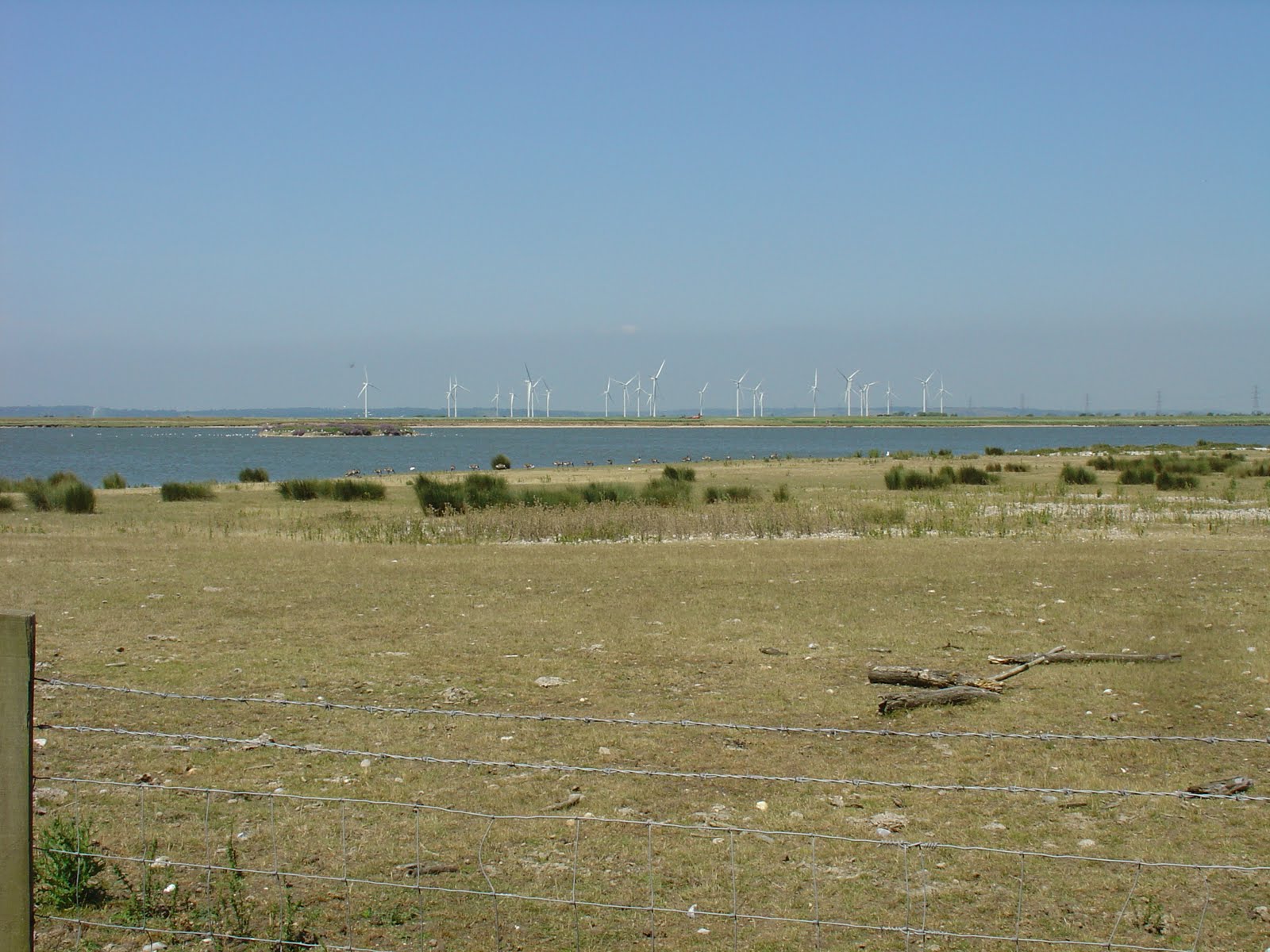
Little Cheyney Court wind farm is clearly visible from the NCN2 between Jury's Gap and Rye. It was opened in 2009. It is claimed that the 26 turbines will generate clean electricity equivalent to the annual electricity demand of three quarters of the homes in the Shepway District Council area. I wonder how much of the time they are actually generating power.
Rye is a humdinger of a town. Its origins date back before the Conquest. From 1205-1247, it came under French rule. As a thriving and important port, in the thirteenth century, Rye along with others, was granted special taxation rights as a Cinque port, in return for which the town had to provide ships and men to the King. (Originally, as the name Cinque Ports suggests, the Confederation originally comprised the five ports of Hastings, Romney, Hythe, Dover and Sandwich).The sea hereabouts has progressively withdrawn. In the 13th century it is said that Rye was a town on a promontory almost surrounded by the sea, with a harbour below. From this time storms caused shingle to accumulate and the surrounding area to progressively silt up. In the 16th century, for example, nearby Camber Castle was built by Henry VIII at the high water line, but by the time of Charles I the sea had receded 2 miles rendering the castle useless. Rye's function as a major port inevitably disappeared, but it seems to have survived as a sleepy market town. There are many fine buildings. There were originally 4 gates, but only the Landgate remains, along with the Ypres Tower. Climb the Church Tower for views over the town to Romney Marsh, and wander the cobbled streets. Visit Lamb House, home of novelist Henry James.
Finding your way: As with any ambitious cycle ride in the UK, it's best to download the route and follow it on a GPS or smartphone app. The route from Dover to Hythe, and Lydd to Rye follows NCN2 and is reasonably well signed. The route across Dungeness is best followed on a GPS.
Photos
 |
Lots of good riding along sea walls (Dymchurch Sea Wall, Looking back to Folkestone)
 | Tunnel to Samphire Hoe
|
|


Comments
Post a Comment