(Afternote: for a shorter loop around the Ventnor Downs, see this later blogpost.)
My previous excursion to the Isle of Wight having whetted my appetite for more, I today made another visit to the Island. This time, my target was the coast along the southernmost tip of the island. I drove down to Portsmouth and parked in the Gunwharf Quays car park (special rate £8 per day if, on exit, you present your IOW ferry ticket receipt at the reception office). It was then a short distance to the Wightlink ticket office at Portsmouth Harbour station, where I bought a day return to Shanklin, covering the crossing on the fast catamaran ferry to Ryde Pier Head, and the train ride from Ryde to Shanklin.
The trains go from Ryde Pier Head, and are old Piccadilly Line tube trains. They comprise two carriages, and in theory will take only four bikes per train, though I think I was the only cyclist on this occasion. The ride is very bumpy so it pays to make sure your bike is securely propped up. Also, the station platforms are sometimes on the left, sometimes the right, so you have to be ready to lift your bike from one side to the other so that it doesn't fall out when the sliding doors open!
My GPS track is here (in maroon). I have added it to the same map as the track for my previous excursion (in blue), so that over time all my rides on the island will be included on one map.
From Shanklin station I took the disused railway (branded as part of the Red Squirrel Trail) westwards for a short distance before branching off South on a bridleway which took me up to the chalk ridge which is comprised of, successively, St Martin's Down, Shanklin Down then Luccombe Down. It was quite a tough climb (I walked some of it), but once on top, there is an excellent grass/chalk track along the chalk ridge, with fine views opening out all around, and wild flowers in abundance. I then picked up the well tarmacced service road for the Ventnor Air Traffic Radar aerials on the top of Bonchurch Down/ St Boniface Down. (I believe all these downs are known collectively as 'Ventnor Downs'. At 235m, St Boniface Down is the highest point on the island.)
I descended on the steep but quiet road to Lowtherville, then descended further on the main road zig zags down to the A3055 coast road to Niton. In 2014, this was blocked by a landslip between St Lawrence and Niton, and discussions are still going on as to what to do about re-opening the road. However, meanwhile, a cycle path has been installed across the landslip, so that there is still a through route open to cyclists. It makes for a pleasant, low traffic ride.
In Niton, I took the track down to Castlehaven Beach, where I had lunch in the garden of the Beach Cafe hut, beautifully located overlooking the sea: a short walk along the cliff took me to St Catherine's Lighthouse, at the southernmost tip of the Island. I now returned Eastwards using the Yar River Trail to cut through to the Ventnor Road (rather busy: presumably it now takes a lot more traffic due to the A3055 closure.) I was glad to turn off onto the good farm track up through Week Farm, which then became a rough chalk track up to the top of Stenbury Down. I made an excursion along the grassy track to see the tumuli on Week Down, another fine viewpoint.
I then descended Northwards past the radio masts on Appledurcombe Down. The path from here round to the Donkey Sanctuary at Lower Winstone Farm (in part following the Worsley Trail) was difficult to cycle: narrow, steep and rough. Actually, I stumbled upon the Donkey Sanctuary by accident, but the cafe was a welcome pit stop for tea, before rejoining the Red Squirrel Trail to return to Shanklin station.
22 miles on a fine high-summer day, with great views and (apart from the above mentioned final stretch from Appledurcombe Down) excellent paths.
My previous excursion to the Isle of Wight having whetted my appetite for more, I today made another visit to the Island. This time, my target was the coast along the southernmost tip of the island. I drove down to Portsmouth and parked in the Gunwharf Quays car park (special rate £8 per day if, on exit, you present your IOW ferry ticket receipt at the reception office). It was then a short distance to the Wightlink ticket office at Portsmouth Harbour station, where I bought a day return to Shanklin, covering the crossing on the fast catamaran ferry to Ryde Pier Head, and the train ride from Ryde to Shanklin.
The trains go from Ryde Pier Head, and are old Piccadilly Line tube trains. They comprise two carriages, and in theory will take only four bikes per train, though I think I was the only cyclist on this occasion. The ride is very bumpy so it pays to make sure your bike is securely propped up. Also, the station platforms are sometimes on the left, sometimes the right, so you have to be ready to lift your bike from one side to the other so that it doesn't fall out when the sliding doors open!
 |
| On board the tube train, Ryde Pier Head |
 |
| Arrival at Shanklin station |
My GPS track is here (in maroon). I have added it to the same map as the track for my previous excursion (in blue), so that over time all my rides on the island will be included on one map.
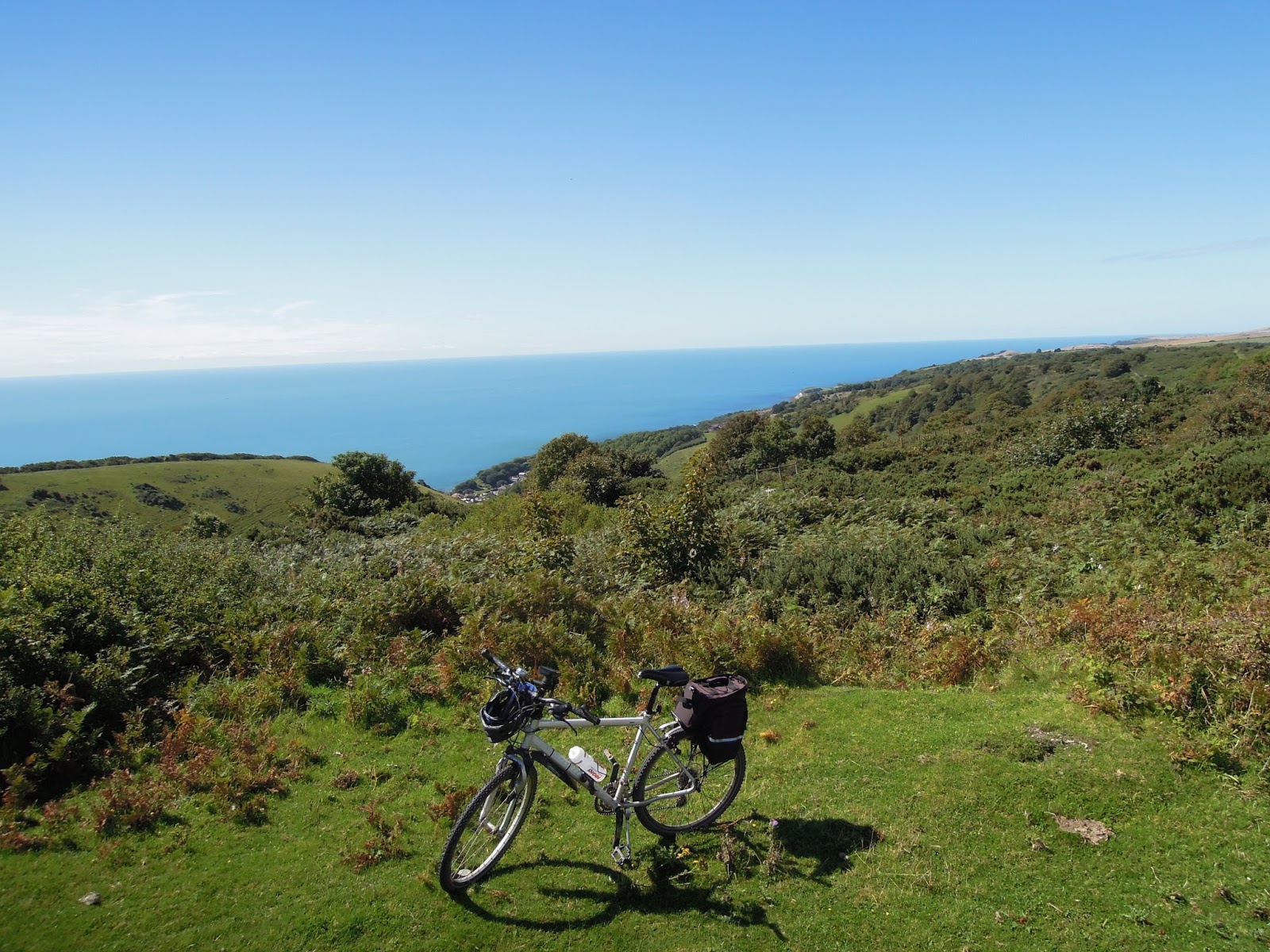
From Shanklin station I took the disused railway (branded as part of the Red Squirrel Trail) westwards for a short distance before branching off South on a bridleway which took me up to the chalk ridge which is comprised of, successively, St Martin's Down, Shanklin Down then Luccombe Down. It was quite a tough climb (I walked some of it), but once on top, there is an excellent grass/chalk track along the chalk ridge, with fine views opening out all around, and wild flowers in abundance. I then picked up the well tarmacced service road for the Ventnor Air Traffic Radar aerials on the top of Bonchurch Down/ St Boniface Down. (I believe all these downs are known collectively as 'Ventnor Downs'. At 235m, St Boniface Down is the highest point on the island.)
 |
| Bridleway up to Ventnor Downs |
 |
| Approaching Shanklin Down |
 |
| On Luccombe Down |
 |
| View over Sandown Bay to Culver Cliff |
 |
| Heather in flower |
 |
| View north from Bonchurch Down |
 |
| Radar station on St Boniface Down |
 |
| View down to Ventnor |
 |
| Descent from Ventnor Downs to Lowtherville |
I descended on the steep but quiet road to Lowtherville, then descended further on the main road zig zags down to the A3055 coast road to Niton. In 2014, this was blocked by a landslip between St Lawrence and Niton, and discussions are still going on as to what to do about re-opening the road. However, meanwhile, a cycle path has been installed across the landslip, so that there is still a through route open to cyclists. It makes for a pleasant, low traffic ride.
 |
| Now-quiet A3055 Undercliff Road |
 |
| Cycle path across landslip |
 |
| Cycle path across landslip |
In Niton, I took the track down to Castlehaven Beach, where I had lunch in the garden of the Beach Cafe hut, beautifully located overlooking the sea: a short walk along the cliff took me to St Catherine's Lighthouse, at the southernmost tip of the Island. I now returned Eastwards using the Yar River Trail to cut through to the Ventnor Road (rather busy: presumably it now takes a lot more traffic due to the A3055 closure.) I was glad to turn off onto the good farm track up through Week Farm, which then became a rough chalk track up to the top of Stenbury Down. I made an excursion along the grassy track to see the tumuli on Week Down, another fine viewpoint.
 |
| St Catherine's Lighthouse from Castlehaven Lane |
 |
| Lunch at Castlehaven Beach Cafe |
 |
| Garden, Castlehaven Beach Cafe |
 |
| Beach and harbour, Castlehaven |
 |
| Castlehaven Beach Cafe |
 |
| Track out of Niton |
 |
| Thatched cottage |
 |
| Yar Valley Trail |
 |
| Track to Week Farm |
 |
| Chalk track up to Stenbury Down |
 |
| On Stenbury Down |
 |
| Top of Stenbury Down |
 |
| Track out to Week Down |
 |
| Tumuli on Week Down |
I then descended Northwards past the radio masts on Appledurcombe Down. The path from here round to the Donkey Sanctuary at Lower Winstone Farm (in part following the Worsley Trail) was difficult to cycle: narrow, steep and rough. Actually, I stumbled upon the Donkey Sanctuary by accident, but the cafe was a welcome pit stop for tea, before rejoining the Red Squirrel Trail to return to Shanklin station.
 |
| Descent of Appledurcombe Down: starts well.... |
 |
| ..... but becomes steep, narrow and rough |
 |
| Worsley Trail: looks nice, but difficult to cycle |
 |
| Arch at back entrance to Appledurcombe Estate |
 |
| Donkey Sanctuary |
 |
| On board train on Ryde Pier: hang on, it's a bumpy ride! |
22 miles on a fine high-summer day, with great views and (apart from the above mentioned final stretch from Appledurcombe Down) excellent paths.
Comments
Post a Comment